Entries Tagged as 'google'

First stage planning for my new #wtrip09

yes… I have already used the hashtag #wtrip09 once this year… but I am planning another road trip at the end of the year…

So here is the new trip, and like #wtrip08 I shall be on the road by myself for a week with to many toys….

remember if you know of something along the way that I should see (or even out of the way on the way…) leave me a comment below.

Melbourne to Brisbane… 6 Days on the Road… and 2,185 km

Day 1: Melbourne to Barmah – 253k

View Larger Map

Day2: Barmah to Hillston – 384k

View Larger Map

Day3: Hillston to Gundaooka National Park – 362k

View Larger Map

Day4: Gundaooka National Park to Charleville – 506k

View Larger Map

Day5: Charleville to Miles – 407k

View Larger Map

Day6: Miles to Brisbane – 335k

View Larger Map

Puffing Billy KML File

After living in Melbourne for 5 years I finally got to do Puffing Billy last weekend…. We did the full return trip from Belgrave to Gembrook. And I left my Nokia N95-8gb running with Sports tracker and created this KML file of the trip. You will notice that in places it jumps a bit which would be due to the thick tree coverage on the route.

Enjoy.

Get the KMZ file here as well


View Larger Map

And my fav photo from the trip…

On Guard

See the previous post for video from the trip as well taken on the D90.

The Drive to Bendigo Video + KMZ File

The Video

175K from home to the Bendigo Art Gallery… Video c/o Logitech Webcam and Asus R2H running at 640×480 10fps

The Route as KMZ File

The KMZ File is made via Sports Tracker on the Nokia 95-8gb exported as KML then quick edit it google earth then uploaded to wolfcat.com.au…. you will also find it on the KML Page


View Larger Map

#wtrip09 – The complete route travelled

Here is the complete KML file of the trip… This covers most side trips as well as the main trip up to Coober Pedy via Roxby Downs


View Larger Map

I still have a few more photos to sort and some video as well.. but at least you can see the whole trip now.

Too Late for Rain

The file is made by exported all the Sports Tracker files from my N95-8gb out to Google Earth, then topping and tailing the file to get rid of the junk from each end of the trip that is more often than not just the gps jumping around.

I have the Oziexplorer track files as well.. but they contain even more noise as I would leave the R2H running a lot longer and also it didn’t come on a number of the smaller drives such as the drive to the Breakaways just outside Coober Pedy.

Finally a draft of the #wtrip08 kmz file

yes.. it has taken way to long to do this.. but with work and all the stuff getting in the way of fun…

anyway here is the first draft of the kmz file for the #wtrip08


View Larger Map

Google Maps Update

No, not the all singing all dancing Google Earth, but the one I use everyday kind of Google Maps.

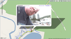
In Melbourne they have finally added two roads… one a small one being the South Road Extension.

And the other being that small road… Eastlink.

The interesting thing is also they are playing catch up with my Nokia.  The Maps on my phone had both of these roads already)…

However Google still have one advantage over my phone and thus why I use them primarily to work out routes to and from places… the large web interface.

I can drag and drop routes and get a quick print out.  Now I know that Nokia have something in the pipeline to do this then transfer that to your phone and when that comes I may stop using google maps as much.  But until then I will.

But unlike a paper map, I have the update, but disappointingly like some things there is no change log or notification of these updates.

Of course there are still glaring errors.  One of the biggest things about driving in Melbourne is the trams…  for starters they don’t get out the way and secondly the will sit behind you and ding the bell if you are trying to do a legal right hand turn because they feel like it.  So when trying to work out where I am going I do tend to avoid roads with trams…..

And Google Maps seems to not have a lot of them…  Hawthorn Road, Caulfield for example has a tram running its entire length…

Sometimes it would be handy to know when the mapping data is from when trying to plan a route.   But then it just could be that I am a mapping nut and no one else actually cares 🙂

Location Location Location (did I mention location?)…

http://code.google.com/android/adc_gallery/

“The final phase of Android Developer Challenge I is now complete. Out of 50 teams of finalists, 10 teams received a $275,000 award each and 10 teams received a $100,000 award each.”

First of all I must say congrats to all the finalists and winners but I must say there is a common theme to a lot of these finalists… 90% of them are location based.  That is no small number and given how google have moved from the search to the location business in the last few years you can see how location is the tech of the future.  A future that is now.

Having a GPS in your car is now considered necessary and unless my taxi driver speaks fluent english and drives a black london cab I want my taxi to have a GPS as well.  But now phones are GPS devices with most manufactures putting them in not only high end models but midrange devices now as well.

I geotagged tweets and photos create KML files e.t.c, but soon and very soon there will be tech that says I am here and what is around me.  Some of these Android apps will flow back into the market on other platforms some more than others.

For example Compare Everywhere will change the face of shopping and shopping districts in a very short period of time.  Image a world where you scan the bar code, your phone then looks around where you are and lets you know if there is a cheaper item online or at another store say walking distance away.  This will not be a small shift in how we shop but will result in a fundimental shift on how shops work.  Perhaps even service will make a come back into a lot of these increasingly homoganised shopping malls.  When a store 3 shops up has something cheaper and you don’t have to go there to find out then you will reconsider you purchases.

Sure a lot of people are going to whine about geoprivacy but like all things there are levels at which you can interact and places you can and wont.  My home is my space for example, but lots of people know where I live and people can work out a lot about you even without computers.  Sure it makes stalking easier, but if we pander to the few bad apples then Newton would never have sat under the apple tree and we would have GPS 🙂

The Face of Google?


The Face of Google?

When Google Street View Australia went live, there were of course some images that made it through…

This is one of them 🙂

12 Patonga Dr, Patonga, NSW Of course they removed it.. but not before the screen dump appeared…

and the SMH has some more mistakes as well.

Street View Australia…

Google  has turned on street View Australia.  but it is not just Capital Cities.  Places like Broome have been done as well.

This image shows the extent for beyond Melbourne for example.

This is the google video for street video Australia…

and more info here on the Google Australia blog

But there are interesting issues as well.  take here for example….

Notice the bits missing. this is not due to any privacy issue.  My GPS always freaks out going through this area called the Black Spur.  The reason, tree density.  The trees are so thick here, that it is hard for the gps to get a fix, espically when moving at speed.   (from the Kml Page this kml shows what i mean)

And round the same area is a road called The Acheron Way.  A single lane dirt road.. and even that has been done, but it also has issues with tree density.

And here are photos of the type of car that Google used.  These were taken in Toorak on December 2 2007. (Click for bigger versions)

Google Street View - Australian Car - Inside

Google Street View - Australian Car

I have also updated the previous post (on boom gate madness) with an iframe to show the google street view in use. By adding in these 360 views you can dramatically expand out a users understanding of an environment.

However you can’t go passed this video to show the power of google maps.

small update :- channel 10 on the late news on 5/8/08 says google street view invades privacy. They of course then go on to say how google will blank out faces or things if you ask them.  Then as the do the voice over on the story they show standard  stock footage of people walking across a pedestrian crossing.  I don’t think they get it yet.

Google Maps and Flash API

http://google-latlong.blogspot.com/2008/05/
news-flash-maps-now-open-to-flash.html

“Rarely does a week go by that I don’t hear from someone who wants to add Google Maps to their Flash application. Well, we’ve been listening and working to provide the solution. Say hello to the new Google Maps API for Flash. ”

more info on the how to here

http://code.google.com/apis/maps/documentation/flash/intro.html

a good example of what you can do here

http://googlemapsapi.blogspot.com/2008/05/introducing-google
-maps-api-for-flash.html

and more examples here

http://code.google.com/apis/maps/documentation/flash/demogallery.html

this is some really neat stuff, and the maps and dynamic timeline examples driven out of a smooth flash interface are really clever.